Acquisition of oldest map of Dutch island Dejima in Japan
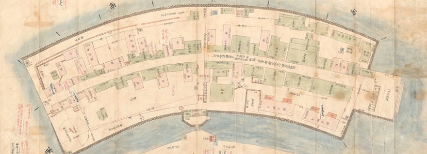
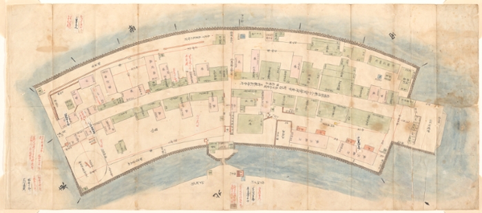
Houses, warehouses, wells, a mooring and even a stable. All of this can be seen on the oldest known map of the island of Dejima acquired by Leiden University Libraries (UBL). The map provides a highly detailed picture of a tiny living environment on the isolated island.
The hand-drawn map of the Dutch East India Company’s (VOC) trading post is an important source for research into Japanese-Dutch history.
This video can not be shown because you did not accept cookies.
You can leave our website to view this video.Detailed map
The hand-drawn map, measuring 87 by 38 cm, depicts the fan-shaped island in great detail. Houses, warehouses and wells are visible around the central street. The landing stage, a stable and the only bridge to the mainland are also depicted. The map was created around 1720 for Japanese officials to enable close monitoring of the Dutch island and its inhabitants. It is a kind of cadastral map: for each building, it indicates who lived there and how much tax they owed. The map has several pasted-on tabs to change the names of people living in certain buildings, indicating that the map was modified over time.
Fan-shaped island
Dejima was an artificial, fan-shaped island off the coast of Nagasaki, Japan. The island was roughly the size of Dam Square in Amsterdam. From 1641 until 1859, Dejima served as a Dutch trading post and was the only location where contact between Japan and Dutch traders was permitted. All other Western powers were denied access to Japan. The Dutch living on Dejima did so under severe restrictions. Only a small number of them were allowed to stay on the island – no more than 20 people at a time – and they were almost completely forbidden from leaving. Additionally, approximately 270 Japanese are known to have worked on Dejima at a time, including translators, food vendors, cooks, servants, firemen, gatekeepers, porters and courtesans.
Collection of maps and atlases
The hand-drawn map of Dejima is a wonderful addition to Leiden University Library’s rich collection of Japanese manuscripts, printed works, maps and atlases. Such a detailed map of Dejima was not yet present in the collection. The acquisition of the map was made possible by an anonymous private donation to the Leiden University Fund.
Text: Leiden University Libraries (UBL)